top of page


Revealing the meter-scale unknown: AI-driven Mississippi Land Cover Mapping with NAIP images
Overview
This project developed and validated an AI-based framework to map the 1-m land cover types and changes in Mississippi using USDA National Agriculture Imagery Program (NAIP) imagery. One of the drawbacks of available land cover products is their spatial resolution (>10m), which has inherent limitations in detecting small targets (e.g., urban tree cover, residential buildings, in-farm reservoirs) and conducting local-specific land cover analysis. The initiative provides an efficient solution under a scarce label context that integrates AI classifier to accurately characterize 1-m land cover types.

Interactive 2023/2016 Mississippi Land Cover Map
Methodology
The specific tasks of this project include: (1) Develop a high-quality land cover training dataset with few representative samples; (2) Implement deep learning semantic segmentation algorithm with two-stage training (self-supervised training & fine-tuning); and (3) Classify the 1-m land cover mapping and provide validated products for Mississippi community.
Training/validation details:
Self-supervised stage: ~377,921 NAIP patch images derived across the MS state
Supervised stage: 1,000 labeled total, with 750 for training and 250 for validation
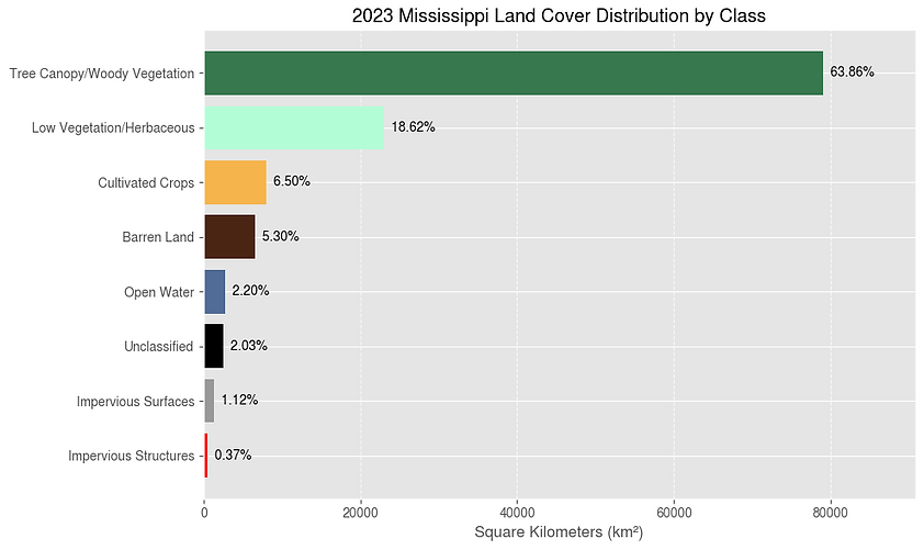
Validation for 2023 product (10,000 random points with visual interpretation): 87.6% overall accuracy
Known Issues
(1) Sun glint on water surfaces is being misclassified as barren land, particularly in open water areas.
(2) Different flight dates in NAIP imagery result in visible striping artifacts in the land cover outputs.
(3) Tree cover and shadows over buildings obscure underlying structures, leading to irregular or imprecise building geometries.
(4) Simplified land cover legend (7 classes) limits certain land cover analysis
Published paper
Outcomes

Product
1-m Land cover maps per country

Codes
(pending)
Deep learning training/prediction codes

Training data
(pending)
Patch-based labels for land cover model training
Funded by

Team

Vitor Martins
Assistant Professor
Dept. of Ag and Bio Engineering
Mississippi State University
Research focus:
Satellite remote sensing
Digital agriculture
Deep learning & HPC solution

Lucas Ferreira
Assistant Professor
Dept. of Ag and Bio Engineering
Mississippi State University
Research focus:
Ag Automation
Deep learning
HPC
Dakota Hester
Graduate Research Assist.
Dept. of Ag and Bio Engineering
Mississippi State University
Research focus:
Remote sensing
Deep learning
HPC

Thainara Lima
Graduate Research Assist.
Dept. of Ag and Bio Engineering
Mississippi State University
Research focus:
Remote sensing
Deep learning
HPC
Contact us
Dept. of Agricultural and Biological engineering
130 Creelman st
Mississippi State, MS 39762
Office: 662-325-3155
bottom of page